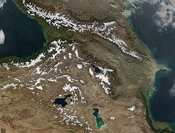
आर्मीनिया का पठार
नेविगेशन पर जाएँ
खोज पर जाएँ
The printable version is no longer supported and may have rendering errors. Please update your browser bookmarks and please use the default browser print function instead.
| आर्मीनिया का पठार | |
तुर्की-ईरान सरहद के पास आर्मीनियाई पर्वत श्रृंखला
| |
| देश | साँचा:flag साँचा:flag/साँचा:flag साँचा:flag साँचा:flag साँचा:flag |
|---|---|
| उच्चतम बिंदु | अरारत पर्वत |
| - ऊँचाई | ५,१३७ मी. (१६,८५४ फीट) |
| - निर्देशांक | साँचा:coord |
| क्षेत्रफल | ४,००,००० कि.मी.² (१,५४,४४१ वर्ग मील) |
आर्मीनिया का पठार (Armenian Plateau) या आर्मीनियाई ऊँचाईयाँ (Armenian Highlands) मध्य पूर्व का एक ऊँचा पठारी इलाक़ा है। यह मध्य पूर्व के बाक़ी दो पठारों - आनातोलिया का पठार और ईरान का पठार - से अधिक ऊँचा है और समुद्रतल से ३,००० फ़ुट (९१० मीटर) की औसत ऊँचाई रखता है। आर्मीनियाई पठार आधुनिक आर्मीनिया, अज़रबेजान, जोर्जिया, उत्तरी ईरान और पूर्वी तुर्की पर विस्तृत है।[१]
इन्हें भी देखें
सन्दर्भ
- ↑ Robert Hewsen, "The Geography of Armenia" in The Armenian People From Ancient to Modern Times Volume I: The Dynastic Periods: From Antiquity to the Fourteenth Century. Richard G. Hovannisian (ed.) New York: St. Martin's Press, 1997, pp. 1-17

