ज़मीनी पुल

ज़मीनी पुल (अंग्रेज़ी: land bridge, लैंड ब्रिज) ऐसे भूडमरू (इस्थमस) या उस से चौड़े धरती के अंश को कहते हैं जिसके ज़रिये समुद्र द्वारा अलग किये हुए धरती के दो बड़े क्षेत्रों के बीच में जानवर आ-जा सकें और वृक्ष-पौधे फैल सकें। हिमयुगों (आइस एज) के दौरान ऐसे ज़मीनी पुल अक्सर उभर आते हैं क्योंकि तब समुद्र के पानी का कुछ अंश बर्फ़ में जमा हुआ होने से समुद्र-तल थोड़ा नीचे होता है। इसका एक बड़ा उदाहरण भारत को श्रीलंका से जोड़ने वाला रामसेतु है। यह हिमयुगों में पूरी तरह समुद्र-तल के ऊपर उभरी हुई ज़मीन की एक पट्टी होती थी जिसपर इतिहास में जानवर चलकर भारत से श्रीलंका पहुँचे थे और भारत से बहुत से पेड़-पौधे भी श्रीलंका में विस्तृत हुए थे। माना जाता है कि आज से लगभग २०,००० साल पहले श्रीलंका के वैदा आदिवासियों के पूर्वज भी इसी ज़मीनी पुल पर चलकर भारत से श्रीलंका पैदल पहुँचे। आधुनिक युग में भारत और श्रीलंका के बीच ४० मील का खुला समुद्र है[१][२][३]
हिमयुगों के अलावा ज़मीनी पुल बनाने के और भी कारण हो सकते हैं। कभी-कभी प्लेट विवर्तनिकी (टेकटॉनिक्स) में भौगोलिक तख़्तों के हिलने से समुद्र के नीचे का फर्श ऊपर उठकर सतह से ऊपर आ जाता है और दो क्षेत्रों को एक पुल बनाकर जोड़ देता है। कुछ इलाक़ों में हिमयुगों के दौरान चलने वाली हिमानियाँ इतनी भारी होती हैं कि उनके नीचे की ज़मीन दब जाती है और हिमयुग की समाप्ति पर बर्फ़ पिघलने के बाद वापस उठ जाती है। कभी-कभी यही हिमयुग-उपरान्त उठी हुई धरती दो क्षेत्रों में पुल बना देती है।
कुछ प्रसिद्ध ज़मीनी पुल
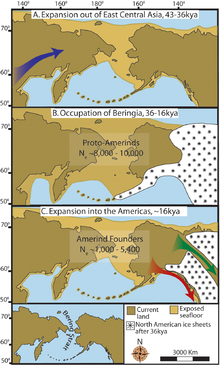
- बेरिंग ज़मीनी पुल (Bering land bridge) - यह एशिया के सुदूर पूर्वोत्तर के साइबेरिया क्षेत्र को उत्तर अमेरिका के सुदूर पश्चिमोत्तर अलास्का क्षेत्र से जोड़ता था। मनुष्य पिछले हिमयुग में इसी पर चलकर उत्तर अमेरिका पहुँचे थे और सभी मूल अमेरिकी आदिवासियों और इनुइतों उन्ही के वंशज हैं। हिमयुग के ख़त्म होने पर समुद्र उठा और यह ज़मीनी पुल डूब गया। अब साइबेरिया के पूर्वतम छोर और अलास्का के पश्चिमतम छोर के बीच ९० किमी समुद्र है।[४]
- पनामा भूडमरू (Panama isthmus) - यह उत्तर अमेरिकी महाद्वीप को दक्षिण अमेरिकी महाद्वीप से जोड़ता है। इन दोनों महाद्वीपों के बीच समुद्र हुआ करता था लेकिन लगभग ३० लाख साल पहले पनामा का ज़मीनी पुल ऊपर उभर आया। इस से जानवरों और पौधों की कई जातियाँ एक महाद्वीप से दूसरे महाद्वीप में फैल गई। इस घटना को जीवविज्ञान में 'महान अमेरिकी अदला-बदली' (Great American Interchange) कहते हैं।[५]
- सीनाई प्रायद्वीप (Sinai peninsula) - यह उत्तर अफ़्रीका को एशिया से जोड़ता है। माना जाता है कि मानव जाति अफ़्रीका में उत्पन्न हुई थी और इस ज़मीनी पुल के द्वारा बाक़ी विश्व में फैली।[६]
इन्हें भी देखें
सन्दर्भ
- ↑ Evolutionary Pathways in Nature: A Phylogenetic Approach, John C. Avise, Cambridge University Press, 2006, ISBN 978-0-521-85753-6, ... Thus, the current separation of the island from the mainland dates only to about 10 000 years ago, when the most recent Ice Age glaciers melted and global sea levels rose once again to create the Palk Strait (the present-day shallow ...
- ↑ Asiaweek, Volume 7 स्क्रिप्ट त्रुटि: "webarchive" ऐसा कोई मॉड्यूल नहीं है।, Asiaweek Ltd., 1981, ... the Indian subcontinent and Sri Lanka, which was then linked to India by a land bridge across the Palk Strait. Into this terrestrial cul-de-sac filtered bands of prehistoric men who anthropologists believe were ancestors of the Veddahs, Sri Lanka's aborigines who still hunt and forage deep in the island's wilds ...
- ↑ स्क्रिप्ट त्रुटि: "citation/CS1" ऐसा कोई मॉड्यूल नहीं है।
- ↑ Prairie Ghost: Pronghorn and Human Interaction in Early America, O'Reilly Media, Inc., ISBN 978-1-4571-0981-2, ... a land bridge—Beringia—connecting the present Chukchi Peninsula of easternmost Siberia with western Alaska was ... the Bering Strait between East Cape, Russia, and Cape Prince of Wales, Alaska, a distance of only 56 miles (90 km) ...
- ↑ A Neotropical Companion: An Introduction to the Animals, Plants, and Ecosystems of the New World Tropics स्क्रिप्ट त्रुटि: "webarchive" ऐसा कोई मॉड्यूल नहीं है।, John C. Kricher, Princeton University Press, 1999, ISBN 978-0-691-00974-2, ... The Panamanian land bridge is responsible for what has become known as the Great American Interchange (Marshall 1988) ...
- ↑ The Evolution and History of Human Populations in South Asia: Inter-Disciplinary Studies in Archaeology, Biological Anthropology, Linguistics and Genetics स्क्रिप्ट त्रुटि: "webarchive" ऐसा कोई मॉड्यूल नहीं है।, Michael D. Petraglia, Bridget Allchin, Springer, 2007, ISBN 978-1-4020-5561-4, ... A commonly hypothesized route of modern human dispersal is a northern route out of Africa, across the Sinai peninsula into the Levant (Bar-Yosef, 1992; Lahr and Foley, 1994; Klein, 1999) ...