चित्र:Punjab-Districts 1911.png
नेविगेशन पर जाएँ
खोज पर जाएँ
इससे ज्यादा रिज़ोल्यूशन उपलब्ध नहीं हैं.
Punjab-Districts_1911.png ((५६९ × ४४८ पिक्सेल, फ़ाइल का आकार: ११३ KB, MIME प्रकार: image/png))
सारांश
| विवरण |
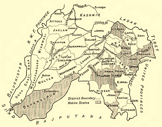
English: Map of the Districts and some Indian Princely States (Bahawalpur, Sirmur, Suket, Chamba etc.) of the Punjab, 1911
Deutsch: Karte der Distrikte des Punjab und einiger darin eingeschlossener indischer Fürstenstaaten (Bahawalpur, Sirmur, Suket, Chamba ), 1911. Höhenangaben in Fuß. |
| दिनांक | |
| स्रोत | Provincial Geographies of India, Vol. III |
| लेखक | Sir Henry |
लाइसेंस
|
This work is in the public domain in its country of origin and other countries and areas where the copyright term is the author's life plus 70 years or fewer. | |
| इस फ़ाइल को कॉपीराइट कानूनों के अंतर्गत सभी संबंधित अधिकारों समेत ज्ञात सीमाओं से मुक्त पहचाना गया है। | |
फ़ाइल का इतिहास
फ़ाइलका पुराना अवतरण देखने के लिये दिनांक/समय पर क्लिक करें।
| दिनांक/समय | अंगूठाकार प्रारूप | आकार | प्रयोक्ता | प्रतिक्रिया | |
|---|---|---|---|---|---|
| वर्तमान | ०८:१२, २९ जून २०१४ | | ५६९ × ४४८ (११३ KB) | wikimediacommons>Xufanc | sepia color |
फ़ाइल का उपयोग
निम्नलिखित पन्ने इस चित्र से जुडते हैं :