चित्र:EIA World Shale Gas Map.png

मुक्त ज्ञानकोश विकिपीडिया से
नेविगेशन पर जाएँ खोज पर जाएँ

मूल फ़ाइल((१,२८० × ७३० पिक्सेल, फ़ाइल का आकार: २१५ KB, MIME प्रकार: image/png))

सारांश

विवरण
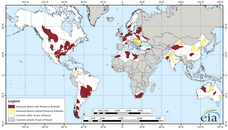
English: Map of major shale gas basis all over the world from the EIA report World Shale Gas Resources: An Initial Assessment of 14 Regions Outside the United States .
दिनांक
स्रोत http://www.eia.gov/analysis/studies/worldshalegas/ the report from 2011: http://www.eia.gov/analysis/studies/worldshalegas/archive/2011/pdf/fullreport.pdf
लेखक Energy Information Administration
दूसरे संस्करण

Update needed with data from recent report: http://www.eia.gov/analysis/studies/worldshalegas/ full pdf 60 mb, overview pdf

लाइसेंस

Public domain This image is a work of a United States Department of Energy (or predecessor organization) employee, taken or made as part of that person's official duties. As a work of the U.S. federal government, the image is in the public domain.

Please note that national laboratories operate under varying licences and some are not free. Check the site policies of any national lab before crediting it with this tag.


العربية  English  français  日本語  македонски  മലയാളം  Nederlands  русский  українська  Tiếng Việt  简体中文  繁體中文  +/−

Captions

Add a one-line explanation of what this file represents

Items portrayed in this file

चित्रण

data size अंग्रेज़ी

२,२०,४१९ बाइट

७३० पिक्सल

width अंग्रेज़ी

१,२८० पिक्सल

media type अंग्रेज़ी

image/png

checksum अंग्रेज़ी

2164eeea42888de9566571ba0c482f3b1250887a

फ़ाइल का इतिहास

फ़ाइलका पुराना अवतरण देखने के लिये दिनांक/समय पर क्लिक करें।

दिनांक/समयअंगूठाकार प्रारूपआकारप्रयोक्ताप्रतिक्रिया
वर्तमान१३:२६, १ फ़रवरी २०१३१३:२६, १ फ़रवरी २०१३ के संस्करण का अंगूठाकार प्रारूप।१,२८० × ७३० (२१५ KB)wikimediacommons>Benger~commonswikiA larger, more readable version.

इस चित्र से कोई पन्ने नहीं जुड़ते

मेटाडाटा