चित्र:Comparison satellite navigation orbits.svg
मुक्त ज्ञानकोश विकिपीडिया से
नेविगेशन पर जाएँ
खोज पर जाएँ

पूर्वावलोकन PNG का आकार SVG फ़ाइल: ५१२ × ५१२ पिक्सेल अन्य resolutions: २४० × २४० पिक्सेल | ४८० × ४८० पिक्सेल | ७६८ × ७६८ पिक्सेल | १,०२४ × १,०२४ पिक्सेल | २,०४८ × २,०४८ पिक्सेल ।
मूल फ़ाइल (SVG फ़ाईल, साधारणत: ५१२ × ५१२ पीक्सेल्स, फ़ाईलका आकार: ४२ KB)

|
यह चित्र एक एनिमेटेड SVG फ़ाइल है। ऊपर का .png पूर्वावलोकन विकिमीडिया पर इस्तेमाल के लिए RSVG द्वारा बनाया गया था, और यह अधूरा या गलत हो सकता है। एनिमेशन देखने के लिए किसी भी आधुनिक ब्राउज़र या वीक्षक में open media:Comparison satellite navigation orbits.svg। इसे किसी भी आधुनिक ब्राउज़र या वीक्षक पर चलना चाहिए। Chrome, Firefox, Microsoft Edge, Safari, और Opera, सभी के नवीनतम संस्करणों पर SMIL से एनिमेट किए गए SVG समर्थित हैं।
दूसरे SVG एनिमेशन Category:Animated SVG files पर देखे जा सकते हैं।
|
सारांश
| विवरणComparison satellite navigation orbits.svg |
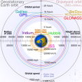
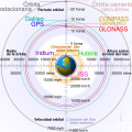
English: Comparison of GPS, GLONASS, Galileo and COMPASS (medium Earth orbit satellites) orbits with International Space Station, Hubble Space Telescope, geostationary and graveyard orbits, and the nominal size of the Earth.
Français : Comparaison des orbites GPS, GLONASS, Galileo, Iridium et Beidou avec celles de la Station spatiale internationale et Hubble ainsi que l'orbite géostationnaire, l'orbite de rebut et la taille de la Terre.
|
| स्रोत | अपना कार्य |
| लेखक | cmglee |
| दूसरे संस्करण |
[सम्पादन] English: Animated Español: Animada Македонски: Анимирано Русский: Мультипликация Українська: Анімація
English: Static Македонски: Обична слика Русский: Обычная картинка Українська: Статичне зображення
|
| SVG genesis InfoField | इस वेक्टर चित्र को unknown tool की मदद से बनाया गया था। This diagram is translated using SVG switch elements: all translations are stored in the same file. |
Assessment
| इस फ़ाइल को 12 अगस्त 2020 का दैनिक प्रदर्शित मीडिया चित्र के रूप में चुना गया था। इसका कैप्शन था:
English: A detailed and informative diagram that brings to life where different satellites (e.g. the International Space Station vs. the GPS satellites) are physically located relative to Earth
Other languages
Čeština: Detailní diagram ukazující, kde se na oběžné dráze kolem Země fyzicky nacházejí různé uměle vyrobené satelity, např. Mezinárodní vesmírná stanice nebo součásti sysému GPS. English: A detailed and informative diagram that brings to life where different satellites (e.g. the International Space Station vs. the GPS satellites) are physically located relative to Earth Français : Diagramme animé présentant les principales orbites des satellites artificiels autour de la Terre.
|

|
This is a featured media on Wikimedia Commons and is considered one of the finest files.
If you have a file of similar quality that can be published under a suitable copyright license, be sure to upload it, tag it, and nominate it.
|
|
लाइसेंस
मैं, इस कार्य का/की कॉपीराइट धारक, इसे निम्न लाइसेंसों के अंतर्गत प्रकाशित करता/करती हूँ:
इस फ़ाइल को क्रिएटिव कॉमन्स श्रेय-समानसांझा 3.0 अनरिपोर्टेड लाइसेंस के अंतर्गत लाइसेंस किया गया है।
- आप खुलकर:
- बाँट सकते हैं – रचना की प्रतिलिपि बना सकते हैं, बाँँट सकते हैं और संचारित कर सकते हैं
- रीमिक्स कर सकते हैं – कार्य को अनुकूलित कर सकते हैं
- निम्नलिखित शर्तों के अंतर्गत:
- श्रेय – यह अनिवार्य है कि आप यथोचित श्रेय प्रदान करें, लाइसेंस की कड़ी प्रदान करें, और अगर कोई बदलाव हुए हों तो उन्हें इंगित करें। आप ऐसा किसी भी उचित तरीके से कर सकते हैं, लेकिन किसी भी तरह उससे यह नहीं संकेत नहीं किया जाना चाहिए कि लाइसेंसधारी द्वारा आपको अथवा आपके इस प्रयोग का समर्थन किया जा रहा हो।
- समानसांझा – अगर आप इस रचना में कोई बदलाव करते हैं या इसपर आधारित कुछ रचित करते हैं तो आप अपने योगदान को सिर्फ इसी या इसके सामान किसी लाइसेंस के अंतर्गत बाँट सकते हैं।

|
इस दस्तावेज़ को Free Software Foundation द्वारा प्रकाशित GNU मुक्त प्रलेख लाइसेंस के संस्करण 1.2 या नए (बिना किसी अपरिवर्तनीय अनुभागों और अगले या पिछले आवरण के टेक्स्ट के) के अंतर्गत प्रतिलिपि बनाने, बाँटने और/या बदलने की अनुमति प्रदान की जाती है। इस लाइसेंस की एक प्रतिलिपि GNU मुक्त प्रलेख लाइसेंस नामक अनुभाग में शामिल है।http://www.gnu.org/copyleft/fdl.htmlGFDLGNU Free Documentation Licensetruetrue |
आप अपना पसंद का लाइसेंस चुन सकते हैं।
| Annotations InfoField | This image is annotated: View the annotations at Commons |
Captions
Add a one-line explanation of what this file represents
Earth satellite orbits
Сравнительные характеристики орбит искусственных спутников Земли
Satelit mengelilingi (orbit) bumi
地球卫星轨道
مدارات الأقمار الصناعية حول الأرض
Items portrayed in this file
चित्रण
some value
source of file अंग्रेज़ी
original creation by uploader अंग्रेज़ी
media type अंग्रेज़ी
image/svg+xml
checksum अंग्रेज़ी
2cf5d382b563a0eac7ecd7322d221f0fb0d6bbbb
data size अंग्रेज़ी
४३,५०२ बाइट
५१२ पिक्सल
width अंग्रेज़ी
५१२ पिक्सल
फ़ाइल का इतिहास
फ़ाइलका पुराना अवतरण देखने के लिये दिनांक/समय पर क्लिक करें।
| दिनांक/समय | अंगूठाकार प्रारूप | आकार | प्रयोक्ता | प्रतिक्रिया | |
|---|---|---|---|---|---|
| वर्तमान | ०४:४८, २७ फ़रवरी २०२१ |  | ५१२ × ५१२ (४२ KB) | wikimediacommons>Glrx | Fix SVG errors: systemLanguage attr on desc element; misuse of switch element; use SVG 2.0 rules; delete DOCTYPE |
फ़ाइल का उपयोग
निम्नलिखित पन्ने इस चित्र से जुडते हैं :
मेटाडाटा
इस फ़ाइल में बढ़ाई हुई जानकारी हैं, हो सकता है कि यह फ़ाइल बनाने में इस्तेमाल किये गए स्कैनर अथवा कैमेरा से यह प्राप्त हुई हैं। अगर यह फ़ाइल बदलदी गई है तो यह जानकारी नई फ़ाइल से मेल नहीं खाने की आशंका है।
| लघु शीर्षक | Comparison of several satellite navigation system orbits |
|---|---|
| चित्र शीर्षक | Comparison of geostationary, GPS, GLONASS, Galileo and BeiDou (medium earth orbit satellites), International Space Station, Hubble Space Telescope, Iridium Constellation and graveyard orbits with the Van Allen radiation belts and the nominal size of the earth, drawn by CMG Lee. Earth bitmap is https://commons.wikimedia.org/wiki/File:North_pole_february_ice-pack_1978-2002.png by Geo Swan. The Moon's orbit is around 9 times larger (in radius and length) than geostationary orbit. The animation runs at 1 hour per second. In the SVG file, hover over an orbit or its label to highlight it, and click to load its Wikipedia article. |
| चौड़ाई | 100% |
| ऊँचाई | 100% |


