चित्र:Commonwealth of Nations.svg
नेविगेशन पर जाएँ
खोज पर जाएँ

पूर्वावलोकन PNG का आकार SVG फ़ाइल: ८०० × ४०६ पिक्सेल अन्य resolutions: ३२० × १६२ पिक्सेल | ६४० × ३२५ पिक्सेल | १,०२४ × ५२० पिक्सेल | १,२८० × ६५० पिक्सेल | २,५६० × १,३०० पिक्सेल | २,७५४ × १,३९८ पिक्सेल ।
मूल फ़ाइल (SVG फ़ाईल, साधारणत: २,७५४ × १,३९८ पीक्सेल्स, फ़ाईलका आकार: १.१ MB)
सारांश
| विवरण |
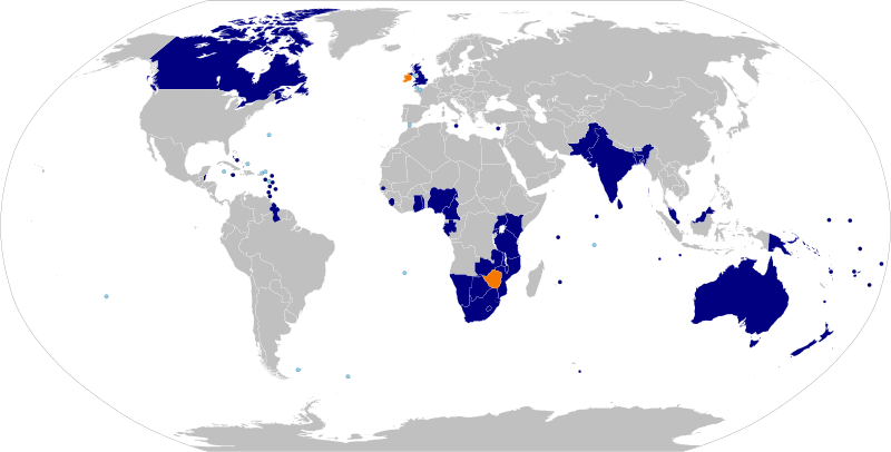
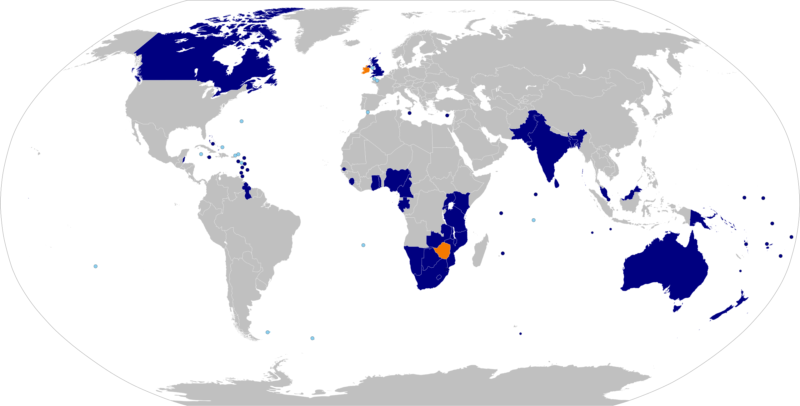
English: Map of the Commonwealth of nations. Based on Image:BlankMap-World6, compact.svg with information from List of members of the Commonwealth of Nations and colour scheme from Image:Commonwealth of Nations.png.
English (en): Commonwealth of Nations
Commonwealth of Nations members Suspended Commonwealth of Nations members (none) British Overseas Territories and Crown Dependencies
Español: Mapa de la Mancomunidad de Naciones. Basado en Image:BlankMap-World6, compact.svg con información de Países miembros de la Mancomunidad de Naciones y esquema de color de Image:Commonwealth of Nations.png.
español (es): Mancomunidad de Naciones
Miembros de la Mancomunidad de Naciones miembros suspendidos (ninguno) Territorios Británicos de Ultramar y Dependencias de la Corona Británica
Deutsch: Karte des Commonwealth of Nations. Basierend auf Image:BlankMap-World6, compact.svg mit Informationen der List of members of the Commonwealth of Nations in der englischsprachigen Wikipedia und dem Farbschema aus Image:Commonwealth of Nations.png.
Deutsch (de): Commonwealth of Nations
Mitglieder des Commonwealth of Nations Suspendierte Mitglieder
Français : Carte du Commonwealth of Nations. Basée sur Image:BlankMap-World6, compact.svg avec des informations de List of members of the Commonwealth of Nations et schéma de couleur de Image:Commonwealth of Nations.png.
français (fr): Commonwealth of Nations
Membres du Commonwealth of Nations Membres suspendus (aucun actuellement)
Hrvatski: Karta država Zajednice naroda. Temelji se na Image:BlankMap-World6, compact.svg i podacima iz Popisa članica Zajednice naroda i paleti boja iz Image:Commonwealth of Nations.png.
hrvatski (hr): Zajednica naroda
Članice Zajednice naroda Suspendirane članice Zajednice naroda Bivše članice Zajednice naroda
Português: Mapa da Commonwealth. Baseado em Image:BlankMap-World6, compact.svg com informação de List of members of the Commonwealth of Nations e esquema de cores de Image:Commonwealth of Nations.png.
português (pt): Comunidade das Nações
Membros Membros Suspensos Territórios Britânicos Ultramarinos e Dependências da Coroa Britânica
Українська: Карта Співдружності націй. Базується на Image:BlankMap-World6, compact.svg з інформацією з List of members of the Commonwealth of Nations та схемою кольорів із Image:Commonwealth of Nations.png.
українська (uk): Співдружність націй
Члени Співдружності націй Призупинені члени Колишні члени Британські заморські території та Коронні володіння
اردو: اقوام دولت مشترکہ کا نقشہ۔ اس نقشہ کا مأخذ File:BlankMap-World6, compact.svg ہے، اس میں ملکوں کی دولت مشترکہ میں رکنیت کا مشمول ڈیٹا، انگریزی ویکی پیڈیا کے مقالہ، Member states of the Commonwealth of Nations (دولت مشترکہ کے رکن ممالک) سے حاصل کیا گیا ہے اور اس کی رنگ بندی File:Commonwealth of Nations.png کے طرز پہ کی گئی ہے۔
اردو (ur): اقوام دولت مشترکہ
ارکان دولت مشترکہ دولت مشترکہ کے معطل ارکان دولت مشترکہ کے سابقہ ارکان سمندر پار برطانوی سرزمین اور غیر آزاد، برطانوی تاج کی ممتلک ریاستیں
|
| दिनांक | (UTC) |
| स्रोत | अपना कार्य, sources given at Member states of the Commonwealth of Nations |
| लेखक | Applysense |
| अनुमति (इस चित्र का पुनः उपयोग करना) |
Public domain. |
लाइसेंस
| मैं, इस कार्य का/की कॉपीराइट धारक, इस कार्य को सार्वजनिक डोमेन में प्रकाशित करता/करती हूँ। यह पूरे विश्व में लागू होता है। कुछ देशों में यह कानूनी तौर पर नहीं हो सकता है; ऐसा हो तो: मैं सभी को इस कार्य का इस्तेमाल किसी भी उद्देश्य से, बिना किसी बाधाओं के इन शर्तों के कानून द्वारा अनिवार्य किए तक करने की अनुमति देता/देती हूँ। |
फ़ाइल का इतिहास
फ़ाइलका पुराना अवतरण देखने के लिये दिनांक/समय पर क्लिक करें।
| दिनांक/समय | अंगूठाकार प्रारूप | आकार | प्रयोक्ता | प्रतिक्रिया | |
|---|---|---|---|---|---|
| वर्तमान | १९:१६, २५ जून २०२२ | | २,७५४ × १,३९८ (१.१ MB) | wikimediacommons>DrKay | added Gabon and Togo |
फ़ाइल का उपयोग
निम्नलिखित पन्ने इस चित्र से जुडते हैं :