चित्र:Zealandia topography.jpg

मुक्त ज्ञानकोश विकिपीडिया से
नेविगेशन पर जाएँ खोज पर जाएँ

मूल फ़ाइल((१,३९१ × १,६१७ पिक्सेल, फ़ाइल का आकार: १.३४ MB, MIME प्रकार: image/jpeg))

सारांश

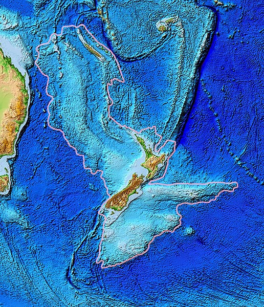
विवरण Topographical map of the Zealandia continent.
दिनांक
स्रोत Ultimate source: ETOPO2v2, a digital database of seafloor and land elevations. Actually cropped from Image:Pacific_elevation.jpg.
लेखक World Data Center for Geophysics & Marine Geology (Boulder, CO), National Geophysical Data Center, NOAA
अनुमति
(इस चित्र का पुनः उपयोग करना)
NOAA, public domain
दूसरे संस्करण Image:Pacific_elevation.jpg, here cropped to focus on Zealandia.

लाइसेंस

Public domain
This image is in the public domain because it contains materials that originally came from the U.S. National Oceanic and Atmospheric Administration, taken or made as part of an employee's official duties.

العربية  čeština  Deutsch  Zazaki  English  español  eesti  suomi  français  hrvatski  magyar  italiano  日本語  한국어  македонски  മലയാളം  Plattdüütsch  Nederlands  polski  português  română  русский  sicilianu  slovenščina  Türkçe  Tiếng Việt  简体中文  繁體中文  +/−

Captions

Add a one-line explanation of what this file represents
Zealandia topography

Items portrayed in this file

चित्रण

submerged continent अंग्रेज़ी

media type अंग्रेज़ी

image/jpeg

फ़ाइल का इतिहास

फ़ाइलका पुराना अवतरण देखने के लिये दिनांक/समय पर क्लिक करें।

दिनांक/समयअंगूठाकार प्रारूपआकारप्रयोक्ताप्रतिक्रिया
वर्तमान१३:२४, २८ मार्च २०१७१३:२४, २८ मार्च २०१७ के संस्करण का अंगूठाकार प्रारूप।१,३९१ × १,६१७ (१.३४ MB)wikimediacommons>Bogomolov.PLcontinent limits with pink

निम्नलिखित पन्ने इस चित्र से जुडते हैं :