चित्र:Vakhsh.JPG

मुक्त ज्ञानकोश विकिपीडिया से
नेविगेशन पर जाएँ खोज पर जाएँ

मूल फ़ाइल((१,०५२ × १,०६६ पिक्सेल, फ़ाइल का आकार: १९९ KB, MIME प्रकार: image/jpeg))

सारांश

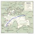
Map showing the Vakhsh River through Kyrgyzstan and Tajikistan. Derived by me from a CIA map located at the Perry-Castañeda Library (PCL) of the University of Texas at Austin map collection here. - Bantman 22:04, August 30, 2005 (UTC)

लाइसेंस

Public domain
This work is in the public domain in the United States because it is a work prepared by an officer or employee of the United States Government as part of that person’s official duties under the terms of Title 17, Chapter 1, Section 105 of the US Code. Note: This only applies to original works of the Federal Government and not to the work of any individual U.S. state, territory, commonwealth, county, municipality, or any other subdivision. This template also does not apply to postage stamp designs published by the United States Postal Service since 1978. (See § 313.6(C)(1) of Compendium of U.S. Copyright Office Practices). It also does not apply to certain US coins; see The US Mint Terms of Use.
इस फ़ाइल को कॉपीराइट कानूनों के अंतर्गत सभी संबंधित अधिकारों समेत ज्ञात सीमाओं से मुक्त पहचाना गया है।

Captions

Add a one-line explanation of what this file represents

Items portrayed in this file

चित्रण

फ़ाइल का इतिहास

फ़ाइलका पुराना अवतरण देखने के लिये दिनांक/समय पर क्लिक करें।

दिनांक/समयअंगूठाकार प्रारूपआकारप्रयोक्ताप्रतिक्रिया
वर्तमान१८:०४, ६ दिसम्बर २००५१८:०४, ६ दिसम्बर २००५ के संस्करण का अंगूठाकार प्रारूप।१,०५२ × १,०६६ (१९९ KB)wikimediacommons>Bantman~commonswikiMap showing the Vakhsh River through Kyrgyzstan and Tajikistan. Derived by me from a CIA map located at the Perry-Castañeda Library (PCL) of the University of Texas at Austin map collection [http://www.li

निम्नलिखित पन्ने इस चित्र से जुडते हैं :

मेटाडाटा