चित्र:Spratly Is since NalGeoMaps.png
नेविगेशन पर जाएँ
खोज पर जाएँ
इससे ज्यादा रिज़ोल्यूशन उपलब्ध नहीं हैं.
Spratly_Is_since_NalGeoMaps.png ((३३० × ३५४ पिक्सेल, फ़ाइल का आकार: ३१ KB, MIME प्रकार: image/png))

|
This locator map image could be re-created using vector graphics as an SVG file. This has several advantages; see Commons:Media for cleanup for more information. If an SVG form of this image is available, please upload it and afterwards replace this template with
{{vector version available|new image name}}.
It is recommended to name the SVG file “Spratly Is since NalGeoMaps.svg”—then the template Vector version available (or Vva) does not need the new image name parameter. |
सारांश
| विवरण |
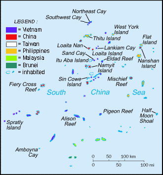
English: Spratly Islands military settlements
Français : Etablissements militaires dans l'archipel des Spratly
Tagalog: Sakop na lupa ng militar sa Pulo ng Kalayaan
中文(简体):南沙群岛的军事区
中文(繁體):南沙群島的軍事區 |
| दिनांक | |
| स्रोत | Cartothèque Spiridon Manoliu |
| लेखक | Spiridon Manoliu |
लाइसेंस
| मैं, इस कार्य का/की कॉपीराइट धारक, इस कार्य को सार्वजनिक डोमेन में प्रकाशित करता/करती हूँ। यह पूरे विश्व में लागू होता है। कुछ देशों में यह कानूनी तौर पर नहीं हो सकता है; ऐसा हो तो: मैं सभी को इस कार्य का इस्तेमाल किसी भी उद्देश्य से, बिना किसी बाधाओं के इन शर्तों के कानून द्वारा अनिवार्य किए तक करने की अनुमति देता/देती हूँ। |
फ़ाइल का इतिहास
फ़ाइलका पुराना अवतरण देखने के लिये दिनांक/समय पर क्लिक करें।
| दिनांक/समय | अंगूठाकार प्रारूप | आकार | प्रयोक्ता | प्रतिक्रिया | |
|---|---|---|---|---|---|
| वर्तमान | ०६:५०, १२ मार्च २०२१ | | ३३० × ३५४ (३१ KB) | wikimediacommons>Mlgc1998 | typo |
फ़ाइल का उपयोग
निम्नलिखित पन्ने इस चित्र से जुडते हैं :