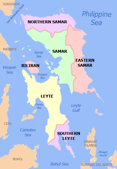
चित्र:Ph eastern visayas.png
मुक्त ज्ञानकोश विकिपीडिया से
नेविगेशन पर जाएँ
खोज पर जाएँ
Ph_eastern_visayas.png ((४०२ × ५८० पिक्सेल, फ़ाइल का आकार: ३७ KB, MIME प्रकार: image/png))

|
This image could be re-created using vector graphics as an SVG file. This has several advantages; see Commons:Media for cleanup for more information. If an SVG form of this image is available, please upload it and afterwards replace this template with
{{vector version available|new image name}}.
It is recommended to name the SVG file “Ph eastern visayas.svg”—then the template Vector version available (or Vva) does not need the new image name parameter. |
सारांश
| विवरणPh eastern visayas.png |
English: Political map of the Eastern Visayas Region, Philippines. Showing Biliran, Eastern Samar, Leyte, Hilagang Samar, Samar and Timog Leyte. Used the map template :Image:BlankMap-Philippines.png by User:TheCoffee. |
| दिनांक | ३ मई २००७ (original upload date) |
| स्रोत | Transferred from en.wikipedia to Commons. |
| लेखक | अंग्रेज़ी विकिपीडिया पर Namayan |
लाइसेंस
अंग्रेज़ी विकिपीडिया पर Namayan, इस कार्य के कॉपीराइट धारक, इसे निम्न लाइसेंसों के अंतर्गत प्रकाशित करते हैं:

|
इस दस्तावेज़ को Free Software Foundation द्वारा प्रकाशित GNU मुक्त प्रलेख लाइसेंस के संस्करण 1.2 या नए (बिना किसी अपरिवर्तनीय अनुभागों और अगले या पिछले आवरण के टेक्स्ट के) के अंतर्गत प्रतिलिपि बनाने, बाँटने और/या बदलने की अनुमति प्रदान की जाती है। इस लाइसेंस की एक प्रतिलिपि GNU मुक्त प्रलेख लाइसेंस नामक अनुभाग में शामिल है।http://www.gnu.org/copyleft/fdl.htmlGFDLGNU Free Documentation Licensetruetrue |
| इस फ़ाइल को क्रिएटिव कॉमन्स श्रेय-समानसांझा 3.0 अनरिपोर्टेड लाइसेंस के अंतर्गत लाइसेंस किया गया है। | ||
| श्रेय: अंग्रेज़ी विकिपीडिया पर Namayan | ||
| ||
| This licensing tag was added to this file as part of the GFDL licensing update.http://creativecommons.org/licenses/by-sa/3.0/CC BY-SA 3.0Creative Commons Attribution-Share Alike 3.0truetrue |
इस फ़ाइल को क्रिएटिव कॉमन्स श्रेय 2.5 साधारण लाइसेंस के अंतर्गत लाइसेंस किया गया है।
श्रेय: अंग्रेज़ी विकिपीडिया पर Namayan
- आप खुलकर:
- बाँट सकते हैं – रचना की प्रतिलिपि बना सकते हैं, बाँँट सकते हैं और संचारित कर सकते हैं
- रीमिक्स कर सकते हैं – कार्य को अनुकूलित कर सकते हैं
- निम्नलिखित शर्तों के अंतर्गत:
- श्रेय – यह अनिवार्य है कि आप यथोचित श्रेय प्रदान करें, लाइसेंस की कड़ी प्रदान करें, और अगर कोई बदलाव हुए हों तो उन्हें इंगित करें। आप ऐसा किसी भी उचित तरीके से कर सकते हैं, लेकिन किसी भी तरह उससे यह नहीं संकेत नहीं किया जाना चाहिए कि लाइसेंसधारी द्वारा आपको अथवा आपके इस प्रयोग का समर्थन किया जा रहा हो।
आप अपना पसंद का लाइसेंस चुन सकते हैं।
मूल अपलोड लॉग
The original description page was here. All following user names refer to en.wikipedia.
| दिनांक/समय | आकार | सदस्य | टिप्पणी |
|---|---|---|---|
| 2007-05-03 06:35 | 402×580× (37892 bytes) | Namayan | Political map of the [[Eastern Visayas|Eastern Visayas Region]], [[Philippines]]. Showing [[Biliran]], [[Eastern Samar]], [[Leyte]], [[Northern Samar]], [[Samar]] and [[Southern Leyte]]. Used the map template [[:Image:BlankMap-Philippines.png]] by [[User: |
Captions
Add a one-line explanation of what this file represents
Items portrayed in this file
चित्रण
some value
source of file अंग्रेज़ी
original creation by uploader अंग्रेज़ी
३ मई 2007
media type अंग्रेज़ी
image/png
फ़ाइल का इतिहास
फ़ाइलका पुराना अवतरण देखने के लिये दिनांक/समय पर क्लिक करें।
| दिनांक/समय | अंगूठाकार प्रारूप | आकार | प्रयोक्ता | प्रतिक्रिया | |
|---|---|---|---|---|---|
| वर्तमान | १९:१६, २८ नवम्बर २०२१ |  | ४०२ × ५८० (३७ KB) | wikimediacommons>Magog the Ogre | Reverted to version as of 13:53, 13 October 2021 (UTC) |
फ़ाइल का उपयोग
निम्नलिखित पन्ने इस चित्र से जुडते हैं :
मेटाडाटा
इस फ़ाइल में बढ़ाई हुई जानकारी हैं, हो सकता है कि यह फ़ाइल बनाने में इस्तेमाल किये गए स्कैनर अथवा कैमेरा से यह प्राप्त हुई हैं। अगर यह फ़ाइल बदलदी गई है तो यह जानकारी नई फ़ाइल से मेल नहीं खाने की आशंका है।
| होरिज़ॉंटल रिज़ोल्यूशन | २८.३५ dpc |
|---|---|
| वर्टिकल रिज़ोल्यूशन | २८.३५ dpc |
