चित्र:North ossetia map.png
नेविगेशन पर जाएँ
खोज पर जाएँ

Version without flag and english name (or miles)
इससे ज्यादा रिज़ोल्यूशन उपलब्ध नहीं हैं.
North_ossetia_map.png ((३०४ × ३७७ पिक्सेल, फ़ाइल का आकार: २३ KB, MIME प्रकार: image/png))

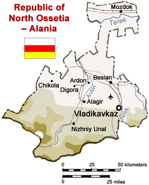
Map of North Ossetia, Russia (from mapping by US Dept of State - 2762 6-94 STATE (INR/GGI))
Originally uploaded to English Wikipedia by ChrisO.
| This image is a work of a United States Department of State employee, taken or made as part of that person's official duties. As a work of the U.S. federal government, the image is in the public domain per 17 U.S.C. § 101 and § 105 and the Department Copyright Information. |  |
फ़ाइल का इतिहास
फ़ाइलका पुराना अवतरण देखने के लिये दिनांक/समय पर क्लिक करें।
| दिनांक/समय | अंगूठाकार प्रारूप | आकार | प्रयोक्ता | प्रतिक्रिया | |
|---|---|---|---|---|---|
| वर्तमान | १३:५०, ६ अप्रैल २००५ | | ३०४ × ३७७ (२३ KB) | wikimediacommons>Dbenbenn | Reverted to earlier revision |
फ़ाइल का उपयोग
निम्नलिखित पन्ने इस चित्र से जुडते हैं :