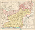
चित्र:Map of Baluchistan from The Imperial Gazetteer of India (1907-1909).jpg

मुक्त ज्ञानकोश विकिपीडिया से
नेविगेशन पर जाएँ खोज पर जाएँ

मूल फ़ाइल((१,००० × ८४४ पिक्सेल, फ़ाइल का आकार: २५४ KB, MIME प्रकार: image/jpeg))

सारांश

विवरण
English: Map of Baluchistan from The Imperial Gazetteer of India Volume 6, opposite page 336.. New edition, published under the authority of His Majesty's Secretary of State for India in Council. Oxford: Clarendon Press, 1907-1909. Scale: 1:6,000,000. 1 in. to 94.6 miles. Native States colored yellow.
दिनांक १९०७ और १९०९ के बीच
date QS:P,+1907-00-00T00:00:00Z/8,P1319,+1907-00-00T00:00:00Z/9,P1326,+1909-00-00T00:00:00Z/9
स्रोत http://dsal.uchicago.edu/maps/gazetteer/index.html
लेखक John G. Bartholomew
दूसरे संस्करण

लाइसेंस

Public domain

The author died in 1920, so this work is in the public domain in its country of origin and other countries and areas where the copyright term is the author's life plus 100 years or fewer.


You must also include a United States public domain tag to indicate why this work is in the public domain in the United States.
इस फ़ाइल को कॉपीराइट कानूनों के अंतर्गत सभी संबंधित अधिकारों समेत ज्ञात सीमाओं से मुक्त पहचाना गया है।

फ़ाइल का इतिहास

फ़ाइलका पुराना अवतरण देखने के लिये दिनांक/समय पर क्लिक करें।

दिनांक/समयअंगूठाकार प्रारूपआकारप्रयोक्ताप्रतिक्रिया
वर्तमान०६:१९, ८ अक्टूबर २०१४०६:१९, ८ अक्टूबर २०१४ के संस्करण का अंगूठाकार प्रारूप।१,००० × ८४४ (२५४ KB)wikimediacommons>Co9manUser created page with UploadWizard

निम्नलिखित पन्ने इस चित्र से जुडते हैं :