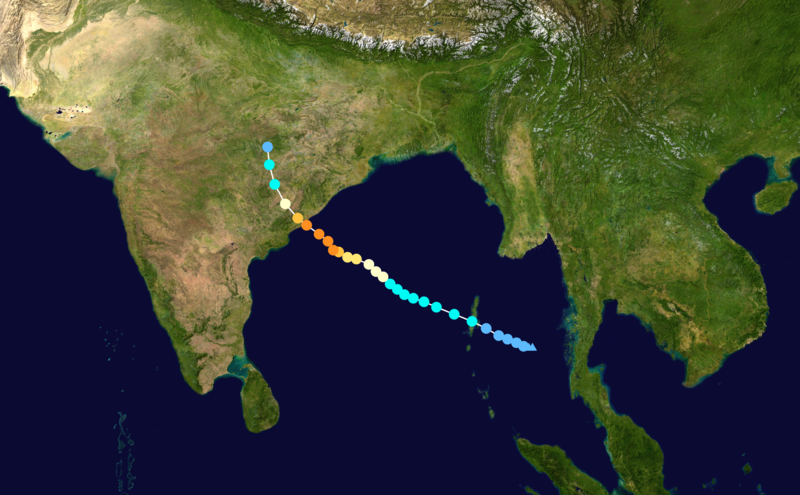
चित्र:Hudhud 2014 track.png
मुक्त ज्ञानकोश विकिपीडिया से
नेविगेशन पर जाएँ
खोज पर जाएँ

इस पूर्वावलोकन का आकार: ८०० × ४९५ पिक्सेल । अन्य resolutions: ३२० × १९८ पिक्सेल | ६४० × ३९६ पिक्सेल | १,०२४ × ६३३ पिक्सेल | १,२८० × ७९१ पिक्सेल | २,७०० × १,६६९ पिक्सेल ।
मूल फ़ाइल ((२,७०० × १,६६९ पिक्सेल, फ़ाइल का आकार: ५.५३ MB, MIME प्रकार: image/png))
सारांश
सारांश
| विवरणHudhud 2014 track.png |
English: Track map of Extremely Severe Cyclonic Storm Hudhud of the 2014 North Indian Ocean cyclone season. The points show the location of the storm at 6-hour intervals. The colour represents the storm's maximum sustained wind speeds as classified in the (see below), and the shape of the data points represent the nature of the storm, according to the legend below. Storm type |
||
| दिनांक | 2014-10-06–2014-10-13 | ||
| स्रोत | Created by Keith Edkins using Wikipedia:WikiProject Tropical cyclones/Tracks. The background image is from NASA. Tracking data is from the Joint Typhoon Warning Center[1]. | ||
| लेखक | Keith Edkins | ||
| Source code InfoField | Track map data table, if present below, is in HURDAT2 or ATCF format. See format details in [2] and [3], respectively.
|
लाइसेंस
| Public domainPublic domainfalsefalse |
| इस कार्य को इसके लेखक, Keith Edkins द्वारा सार्वजनिक डोमेन में प्रकाशित किया गया है। यह पूरे विश्व में लागू होता है। कुछ देशों में यह कानूनी तौर पर नहीं हो सकता है; ऐसा हो तो: Keith Edkins सभी को इस कार्य का इस्तेमाल किसी भी उद्देश्य से, बिना किसी बाधाओं के इन शर्तों के कानून द्वारा अनिवार्य किए तक करने की अनुमति देता/देती हैं। |
Captions
Add a one-line explanation of what this file represents
Items portrayed in this file
चित्रण
फ़ाइल का इतिहास
फ़ाइलका पुराना अवतरण देखने के लिये दिनांक/समय पर क्लिक करें।
| दिनांक/समय | अंगूठाकार प्रारूप | आकार | प्रयोक्ता | प्रतिक्रिया | |
|---|---|---|---|---|---|
| वर्तमान | ०६:०४, १० जुलाई २०१५ |  | २,७०० × १,६६९ (५.५३ MB) | wikimediacommons>Cyclonebiskit | JTWC best track |
फ़ाइल का उपयोग
निम्नलिखित पन्ने इस चित्र से जुडते हैं :